
This seventeen days trek, though rigorous is quite popular because it traverses a great cross section of Bhutan as it winds from the Paro valley in Bhutanese middle hills, up to Laya and Lingshi in Northwest Bhutan which are situated above 4000m. Fewer visitors a year make their way into Laya, one of the most culturally and ecologically pristine regions in the long arc of the Himalaya. The scenery along the way, past the elegant Mount Chomolhari is awe-inspiring with views of alpine landscape with snowcapped mountains and mirrored crystal lakes dotted with yak hair tents of the migratory yak herders.
DAY 01: FLY INTO PARO
Flying into the country’s only airport, in the beautiful Paro valley, the clear mountain air, forested ridges, imposing monasteries and welcoming Bhutanese people in their striking national dress, provides a breath-taking first impression.
Your guide who is going to be with you throughout your trip from our company will meet you at the airport. A fifteen minute drive follows the narrow winding road to our hotel which is a traditional Bhutanese building with attractive gardens and an exceptionally peaceful atmosphere. In the afternoon, we will visit the Ta-Dzong which was built in 1651 as a watch tower for the Rinpung Dzong. Since 1967, the watch tower has served as the home of the National Museum and holds a fascinating collection of art, ancient relics and religious artifacts. Next in line is Rinpung Dzong built in 1646 by Shabdrung, the first spiritual and temporal ruler of Bhutan, the Dzong houses the monastic body of Paro and its district administration. If there is time, we will walk along the small main street of Paro in the evening with its typically Bhutanese shops and small lodges. Altitude at Paro – 2250 meters.
Overnight: Hotel in Paro
DAY 02: DRUKGYAL DZONG – SHANA ZAMPA, 17KMS, 5-6 HRS
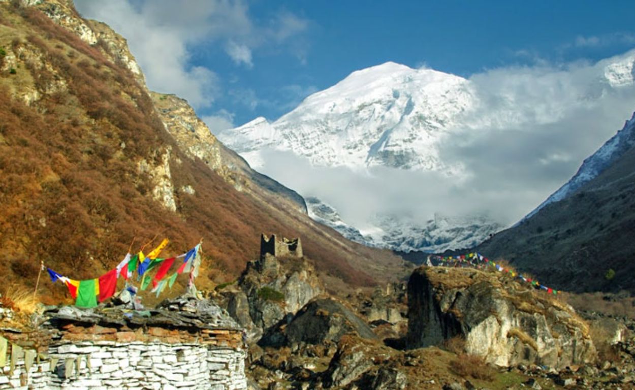
After early breakfast we will drive to Drukgyel Dzong (2,580m), 16 kms from Paro town built in 1647 by the great Shabdrung Ngawang Namgyal, the Dzong was destroyed by accidental fire and left in ruins as an evocative reminder of the great victories it was built to commemorate. Explore the ramparts, village and on a clear day experience the spectacular view of Mt. Chomolhari (7,316m).
The trek starts from here with a short downhill walk on a wide trail. After descending about a while, you reach the river where a primitive stone bath has been carved into the bank. Look back and see how well positioned the Dzong was to keep watch over this valley. Continue your trek up the river through a narrow agricultural valley.
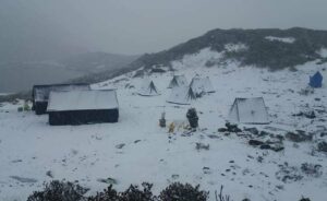
Overnight: Tented Camp – Shana (2870m).
DAY 03: SHANA ZAMPA – THANGTHANGKHA, 22 KMS, 6-7 HRS
The trail continues its gradual climb alongside the Paro Chu (river) through conifers and rhododendron. In places it is quite close to the river; if the water is high you might have to climb over a few small hills to get around places where the water has flowed onto the trail. About 15 minutes beyond Shana Zampa are the remnants of an old bridge with a house and a Chorten on the other side. At this point the route enters Jigme Dorji National Park.
The trail makes continuous, but gentle, climb on a rocky trail through Oaks, rhododendron and ferns, crossing several small streams till where there is a small stone shelter and a Bhutanese style house in a cedar grove at the edge of the meadow.
Overnight: Tented Camp – Thangthangka (3630m)
DAY 04: THANGTHANGKHA – JANGOTHANG, 19 KMS, 5-6 HRS
If you did not see Mount Jhomolhari last evening, you will have a great chance to get a great view this early morning. This morning, the trek continues up the Pachu valley which widens into patches of alpine meadow and meager growths of forest. Cross an army outpost along the way and enjoy a spectacular view of high mountain ridges and snow-capped peaks. Yaks and yak herder’s homes become a regular feature of the landscape. Passing the villages Soe, Takethang and Jangothang is another asset on this day. Reaching Jangothang, one of the most beautiful campsites of the Himalayas, you will again have a spectacular view of Mount Jhomolhari.
Overnight: Tented Camp – Jangothang (4090m)
DAY 05: A DAY HALT & EXPLORATION IN JANGOTHANG.
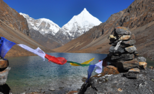
The day in Jangothang provides plenty of possibilities for day hikes with great views on lakes and snow capped mountains such as Jhomolhari and Jichu Drake. There are good chances to spot some blue sheep on the upper slopes of the valley. Jangothang is a perfect environment for your acclimatization. Trek up to Tsophu or hike around the area. There are good short hiking trails in three directions. Jhomolhari and its subsidiary mountain chains lay directly west, Jichu Drake to the north and a number of unclimbed peaks to the east.
Overnight: Tented Camp – Jangothang (4090m)
DAY 06: JANGOTHANG – LINGSHI 18 KMS, 5-6 HRS
After a short walk from the camp, the trail climbs rapidly for about half an hour and then becomes a gradual ascent to the Nyilila pass (4,870m). You might see herds of blue sheep grazing on the slopes of the mountains. From the pass you will have spectacular views of Mt. Jhomolhari, Jichu Drake and Tsherimgang, all of them rising above 7,000m. On the way down to the camp you will pass by some of the yak herder’s tent, made from yak wool, where the herders take shelter while on the move to various pastures for their yaks. As you come down into the Lingshi basin, you get a wonderful view of Lingshi Dzong on a clear day. Tserimgang and its glaciers rise up at the northern end of the valley. The campsite is next to a large stone community hall that is used by both Bhutanese travelers and trekking groups.
Overnight: Tented Camp – Lingshi (4010m)
DAY 07: LINGSHI – CHEBISA, 10 KMS, 5-6 HRS
Cross the stream below the camp on a wooden bridge and climb up the opposite side to a Chorten just below Lingshi Dzong. In the valley to the east is a cluster of wood shingled houses which is one part of Lingshi village. If you look back at Tsering Kang you can see a very distinct rock pinnacle sticking up at the end of the East Ridge. The climb is gradual and easy. The camp site is on a meadow just opposite the Chebisa village (3880 m).
Overnight: Tented Camp – Chebisa (3880m)
DAY 08: CHEBISA – SHOMUTHANG, 17 KMS, 6-7 HRS
This morning, we have a big uphill climb along the vast meadow till Gobula pass (4440m). As we climb up slowly, we may see some blue sheep grazing in high yak pastures and some vultures flying high and handsome in the clear blue sky. After the Gobula pass, it’s mostly downhill to our camp beside a stream through the forests of junipers and firs.
Overnight: Tented Camp – Shomuthang (4260m)
DAY 09: SHOMUTHANG – ROBLUTHANG, 18 KMS, 6-7 HRS
We have a short steep climb and then the trail is level before it gradually starts to climb up the valley crossing the stream for a few times. On this stretch of our trek, we can see lots of edelweiss flowers and we can also have the view of snowcapped peak to the south-east called Khang Bum (6526 m). Once we are at Jhari La (4747 m), the trail goes steep down for about two hours through dwarf rhododendrons, junipers and firs till the campsite. If you are here in the summertime, there will be hundreds of takins to be seen grazing on the slopes of the nearby hills for this valley is a chosen summer home.
Overnight:Tented Camp – Robluthang (4160m)
DAY 10: ROBLUTHANG-LIMITHANG, 19KMS, 6-7 HRS
Today we have a long, hard day, crossing Sinchu La, the last and the highest pass on the trek. It’s a tough climb from here to the pass because the high altitude will slow you down considerably. Passing a false summit with a cairn, the trail levels out a little before reaching some rock cairns and prayer flags on Sinchu La (5005m). The snow covered peak of Gangchentag fills the horizon to the north.
The descent is on a rough, rocky trail that follows a moraine into another glacial valley. It’s then a short walk on a good trail through a cedar forest interspersed with small meadows to Limithang (4140m), a lovely camp site in a big meadow by the river. The peak of Gangchentag towers over the campsite, even though it’s quite a distance away.
Overnight: Tented Camp – Lingmithang (4140m)
DAY 11: LIMITHANG-LAYA, 10 KMS, 4-5 HRS
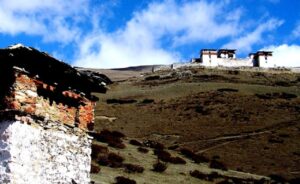
Today its mostly downhill along a winding river, the trail splits, one going down with the river to the camp site used by the army. The other stays high and takes you into the West Side of Laya Village. We will camp on a high flat bench above the East End of the Laya village (3800m).
Overnight: Tented Camp – Laya (3800m)
DAY 12: LAYA – KOINA, 19 KMS, 6-7 HRS
The trail exits the village through a Khonying (arch Chorten), then passes another Chorten at Taje-kha as it descends on a muddy trail to a stream. There are a few houses near the trail, but it’s mostly deep forest all the way to the river. The route follows the Mo Chhu down stream all the way to Punakha. Beyond the army camp the trail goes uphill, crossing a few streams and making little ups and downs. About half an hour from the army post is an inconspicuous trail junction at 3340m. The route for the Snowman Trek leads uphill from here on a tiny path. The route to Gasa keeps going downstream on a muddy trail. The muddy trail stays high for about half an hour until it reaches a stone staircase, where it turns into a side valley, traversing for a bit, then dropping to a large stream. Welcome to Koina (3050m), a muddy bog in the forest by the bridge. There is a single stone house with some muddy camping places scattered around.
Overnight: Tented Camp – Koina (3050m)
DAY 13: KOINA TO GASA TSACHU (TSACHU-HOT SPRING), 14 KMS, 6-7 HRS
You may think that because you are headed downstream this trek is finished, but there’s another major ascent ahead to get over Bari La, which crosses a side ridge. Cross the bridge at Kino and start up the hill ascending to Bari La at 3900m. There’s a small rock cairn and a few prayer flags at the pass, then its reasonably level walk to another Chorten. The route starts down again, sometimes steeply, through a bamboo forest to a stream. At 3080m it rounds a corner where you can finally see Gasa Dzong on the opposite side of a large wooded side valley. Continue walking until you reach Gasa Tsachu (hot spring at 2240m), your night halt for tonight will be here.
Overnight: Tented Camp – Gasa Tsachu (2240m)
DAY 14: GASA-PUNAKHA
The road begins a long descent to the river, first winding down gently in the jungle past a few streams, then switch backing steeply down on a rocky trail in the shadow of a huge rock. After a long descent you will cross a wooden bridge over a side stream at 1960m. The trail now makes small ups and downs close to the river, passing a big cave under a rock. You may encounter rhesus monkey playing alongside the river. The main valley is still much closed in with sub-tropical vegetation such as wild banana trees, creepers and orchids. After a short walk to forestry office of Tashithang you will meet with your vehicle, which will drive you down south for an hour to Punakha.
Overnight: Hotel in Punakha.
DAY 15: PUNAKHA – THIMPHU – PARO
After breakfast you will resume your drive back to Thimphu, on your way back you will once again stop at the Dochula Pass to witness the Panoramic view of Bhutan’s snow capped peaks that stretches about 200 miles long. Continue your drive down to Thimphu and lunch will be served you will have a few hours here before you proceed to Paro.
Overnight: Hotel in Paro
DAY 16: PARO DEPART
After breakfast in the hotel, drive to the airport in time to catch up your onward flight. Your escort from our company will bid you farewell and soon the remote and legendary Dragon Kingdom disappears again behind its guardian mountains.
Recommended season: April, May, June, September, October & November